
Requires an LP360 Drone, an LP360 Land Standard or an LP360 Geospatial license.
The Affine Transform Raster Point Cloud Task (PCT) is a powerful tool designed to modify the coordinates of raster datasets. It is commonly used for:
- Grid-to-ground conversions
- Local site calibrations
- Raster debiasing and alignment
- Applying horizontal and vertical rotation, scale, and translation
- Transforming elevation surfaces and other georeferenced raster products
This task supports both component-based transformations (Rotate, Scale, Translate) and direct matrix input, making it flexible for a wide range of geospatial workflows.
If you are looking to transform a LAS check Affine Transform LAS PCT.
Parameters
Input Datasets
Select the data to which to apply the affine transform.
- Feature Geometry - Defines the area to apply the affine transform.
- Input Raster Layer - Select the raster dataset to use in the processing.
Transformation Settings
-
Rotate: Specify rotation angles (typically in degrees) around the X, Y, or Z axis.
- Select the order of the axis of rotation, "X,Y,Z" or "Z,Y,X". The latter is the default.
- Scale: Enter scale factors for each axis.
- Translate: Input translation values to shift the raster dataset.
- Origin: Define the origin point for rotation and scaling operations.
Matrix Settings
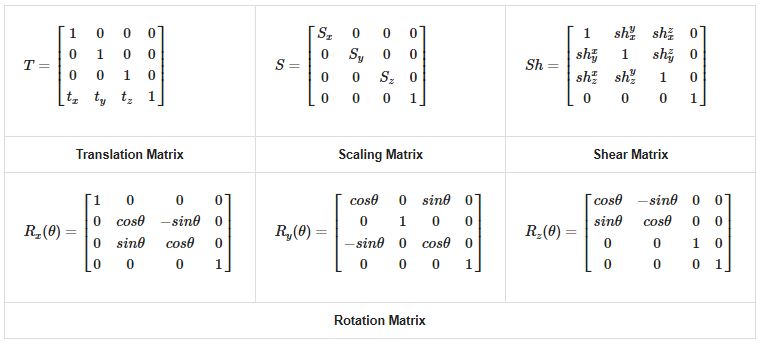
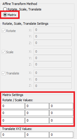
If you prefer matrix math, input the 3x3 transformation matrix and translation vector directly.
- Enter the Rotate / Scale Values in the 3×3 matrix.
- Enter the Translate XYZ Values for the translation vector.
- Use Load From File to import transformation parameters from a saved file.
- LP360 will auto-calculate the matrix from component inputs if both are used.
Output Settings
- Output Folder: Select an output location to write the transformed raster dataset.
- JPEG Compress: Enables JPEG compression to reduce output file size.
- Quality: Sets the JPEG compression quality level.
- Create Pyramids: Generates image pyramids to improve display performance when zooming and panning large raster datasets.
- Enable BigTIFF: Creates the output as a BigTIFF file when the raster size exceeds standard TIFF limitations.
- GeoTag as Local CRS: Tags the output raster with a local Spatial Reference System (SRS), also known as a local Coordinate Reference System (CRS), including the selected units (for example, International Feet or Meters), indicating the raster is stored in a non-standard or arbitrary Local Coordinate System (LCS).
- Local CRS Units: Defines the coordinate units assigned when GeoTag as Local CRS is enabled.
Workflow: Applying Affine Transform Raster PCT
-
Create the Task
- In LP360, go to the Point Cloud Task Manager
.
- Add a new task and select Affine Transform Raster as the type.
- In LP360, go to the Point Cloud Task Manager
-
Configure Parameters
- Select the Input Raster Layer.
- Input Rotate, Scale, Translate values or use matrix input.
- Set the origin if needed.
-
Configure Output Settings
- Select the output folder.
- Configure compression, pyramids, and BigTIFF settings as required.
- Optionally enable GeoTag as Local CRS.
-
Run the Task
- Execute the task using the Point Task tab.
- Verify the output using visual inspection, survey control, or comparison with reference data.
-
Export the Task
- Save the task as an XML file for reuse or batch processing.
- Ensure only the Affine Transform Raster PCT is selected during export.
Comments
0 comments
Please sign in to leave a comment.