Requires a Strip Align addon license and LP360 Drone.
LiDAR Calibration in the Utilities section of the Sensor Tab can be used to estimate constant parameters, the boresite angles, but would not be suited to remove inconsistencies in the point cloud generated by dynamic sensor trajectory errors, which are better handled Strip Adjustment
or Strip Align
. Refer to the method and context behind Strip Adjustment and how to use Strip Adjustment for correcting dynamic sensor trajectory errors.
Strip calibration would not normally be used in a project workflow. In general, this mode should only be used under GeoCue supervision or by advanced users, since an incorrectly updated calibration can affect the performance of the sensor. This tool has been implemented to help users refine their lidar boresight calibration should the need arise from time to time.
Recommended: Review the Boresight Calibration section of the Flight Planning for LiDAR document to learn how to plan an appropriate boresight calibration flight.
Figure 1: Boresight Calibration dialog
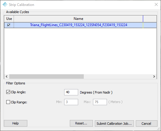
Input
Available Cycles: The list of Cycles in the project which may have their lidar boresight calibration processed.
Use: Select the checkbox in the “Use” column beside a Cycle to determine corrections for that Cycle. The Cycle must have a processed sensor trajectory in the typical file structure when following the Sensor workflow.
Filter Options
The Geocoding options are listed here as the Boresite Calibration process will geocode a new point cloud from the raw data. Typically, use the same options you would for Geocoding
.
Note: The LiDAR Boresite Calibration does not generate a point cloud as a result.
Submit Calibration Job
Submits the calibration processing to the Job Manager queue for processing.
How to Perform a LiDAR Boresite Calibration
- Select Lidar Calibration
on the Sensor Tab to open the Boresite Calibration dialog (Figure 1).
- A successfully submitted job notification will appear confirming the job submission (Figure 2).
Figure 2: Boresite Calibration Job Submission Confirmation
- An empty e-mail will be sent when the processing begins, and ends, to the e-mail configured in the LP360 Notification Email. Strip Calibration will generate a new "SystemConfiguration.json" file as a result in the applicable SADJ job folder. LiDAR Calibration does not generate a point cloud as a result of the job.
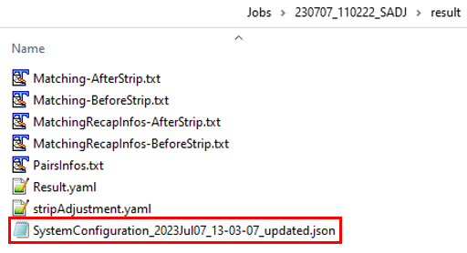
Figure 2: Boresite Calibration results
- The calibration job progress may be monitored using Job Manager
. Job Manager will indicate completion by the green checkmark
flashing on the Job Manager icon.
- Once the email confirmation is received stating that this process is complete, the user can then open Job Manager
-
- Select View Log to review the calibration processing log.
- Review the STDERR section for any reported errors.
- Select Open Project to re-open the applicable project for the job if not already open.
- Once in the project, select Complete Job.
- The new System Configuration file created from this calibration process will then be moved from the job folder and will replace the System Configuration file in the Project\Area\Cycle\System folder. The original System Configuration file located in the Project\Area\Cycle\System folder will be renamed SystemConfigurationBackUpBeforeStripCalibration.json.
- Run Geocoding
, the updated System Configuration file will be used to create the new LAS files.
- Review the results.
- If desired, provide GeoCue Support with the updated SystemConfiguration json file to have it posted to Reckon for availability when running Create TV Trajectories while processing subsequent Cycles from this payload.
- Select View Log to review the calibration processing log.
-
Comments
0 comments
Please sign in to leave a comment.