Introduction
Trimble CenterPoint RTX © is a global GNSS technology that provides centimeter-level positioning, worldwide, at any time. Users may use this service, much like the United States NOAA's Online Positioning User Service (OPUS), or other national and private services, and submit a base station RINEX file to obtain coordinates for that survey nail/reference mark, which can then be entered into the Survey Nail Manager for processing sensor trajectory solutions.
For users running POSPac UAV or POSPac MMS desktop, one may also run Trimble CenterPoint RTX from directly within the generated POSPac project, however, to integrate its usage for all users, this service option was integrated within the sensor Trajectory Processing Wizard in LP360 Drone as of v2022.1.22.0.
Prerequisites
Antennas must be on the Supported Antennas list. The post-processing service will not process unsupported antennas.
- Data formats accepted include Trimble proprietary data formats (e.g. DAT, T01, T02, T04, Quark) and the standard RINEX 2 and RINEX 3 data formats
- For optimal processing results, it is recommended to provide at least 60 minutes of observations.
- Data files cannot exceed 24 hours in length
- Data files must be static only
- Data files must contain dual frequency pseudorange and carrier phase observations (L1 and L2)
- Data must have been collected after 14 May 2011
- BeiDou data is included since 04 Jun 2014
- Galileo data is included since 01 Jan 2017
How to us Trimble CenterPoint RTX to compute your survey nail/reference mark for your base station?
LP360:
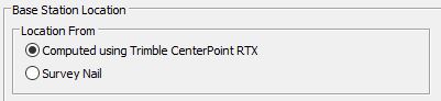
- On the second page of the Trajectory Processing Wizard
toggle the Base Station Location to "Computed using Trimble CenterPoint RTX" to use the computed position rather than entering a survey nail/reference mark in the Survey Nail Manager
and selecting a nail on this page of the wizard.
POSPac Desktop:
- Open the POSPac project generated by LP360.
- Select the base station.
- Right-click and select Compute PP-RTX coordinates.
- It’ll provide a summary on the quality.
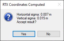
- Select yes to update the base coordinates in the POSPac project with the new values.
- POSPac will download the xml version of the report, like you would get by going to the website directly and puts it into the C numbered folder found beneath the POSPac project.
- You'll also find an rtxCoords_StationID_Mission 1.log in the extract folder.
Comments
0 comments
Please sign in to leave a comment.