About Buffer Classifications
Buffer classifications (or Ignored Ground in the USGS Lidar Base Specification) are those classes that are assigned to LAS points that are within a buffer, i.e. user defined distance, of breaklines. Points that are assigned to these classes are excluded from the surface when using breakline enforcement.
Typical distances used are one quarter to one half the nominal pulse spacing of the point cloud but may be as much as the nominal point spacing. Depending upon the buffer distance, the resulting enforcement will result in the surface tapering to the breakline, instead of a dramatic vertical sliver in the surface. Technical feasibility drives the main need for a buffer around breaklines. On many occasions points may fall on or very close to a breakline. When a point falls on or close to a breakline, and has a slightly different elevation value it can create a condition for a potential error in the TIN generation as a TIN does not allow for two different vertical values at the same XY location. The closer in XY that two elevation values are, the closer in elevation they must be. Otherwise, the TIN generation fails as the slope of the triangle approaches infinity resulting in a failure to create the triangle for the surface at that location. These points are put on the buffer classes for breakline enforcement only. When no breakline enforcement is used, the buffered points should be selected as part of the ground classes when modifying the Display Filter, otherwise gaps (i.e., the buffer around breaklines) in the LIDAR data will be prevalent.
Buffer Filter
Points can be classified into a buffer class using the Classify by Features Point Cloud Task (PCT). This allows the classification of points using a spatial relationship with features. Specifically applicable to buffering, is the "Within a distance of" option. Again, the distance would usually need to be one quarter to one half the nominal pulse spacing of the point cloud.
Define Buffer Class
To make use of the buffer class during the enforcement of breaklines there is an option in the Breakline Enforcement dialog to designate which class will be used as the buffer class. This tells the software not to use those buffer classes in the TIN generation.
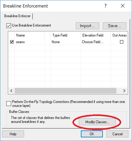
Breakline Enforcement dialog- Modify Classes
NoteIf your LAS files are version 1.4, 256 classes can be defined for a LAS point. Previous versions of LAS files (1.3 and below) allow 32 classes.
|
Why do you need to use buffers around breaklines?
LIDAR points are so dense that when introducing breaklines into a surface using LIDAR points, the points overwhelm or over-weight the introduced breaklines. By removing a buffer of LIDAR points around the breaklines, the weight of the points against the breaklines are reduced allowing the surface to be "constrained" to the breaklines.Technical feasibility also dictates the need for a buffer around breaklines. On many occasions points may fall along the edge of a breakline. Using breaklines when triangulating, requires that no triangle edge can cross a breakline thus allowing the surface to be "enforced" by the introduced breaklines. When a point falls along the edge of a breakline, a zero area triangle is formed between the LIDAR point and breakline segments. This condition creates the potential for division by zero errors and fails to create a surface.
Comments
0 comments
Please sign in to leave a comment.