To reproject a raster in LP360 you will need to establish the source Spatial Reference System (SRS)* if one does not already exist.
- Right-click or double-click on the raster layer, selecting Properties, SRS tab, which will appear empty (Figure 1) if the raster that was added did not have any SRS.
- Select the ellipsis [...] button in the top right of the dialog.
*Aka Coordinate Reference System (CRS)
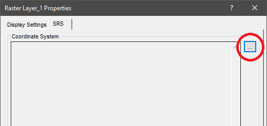
Figure 1: CRS or SRS tab of Layer Properties
- The Select Coordinate System dialog will appear.
- Select the appropriate horizontal and vertical coordinate systems for the source raster. Press “OK” to set on the layer.
Figure 2: Select Coordinate System dialog
- Now that your source SRS is setup, select the Point Cloud Tasks Tab at the bottom of the Table of Contents. Towards the top of the tab should be a dropdown menu where you can select your point cloud task (Figure 3, #1). Here you will select your Reproject Raster Point Cloud Task. If you have not added this point cloud task type yet to your library, see Adding a Point Cloud Task.
- Choose the raster layer you want to reproject as the “Input Raster Layer” (Figure 3, #2). If you only have one raster layer in the project, it will be automatically selected.
- Check the “Convert SRS” checkbox and select your target SRS after clicking on the ellipsis [...] button to the right (Figure 3, #3).
- Then, choose where you wish to save the new raster file under the “Output Folder” box (Figure 3, #4). Hint: Use the <LP360_Project_Folder> variable to help keep this PCT usable across projects.
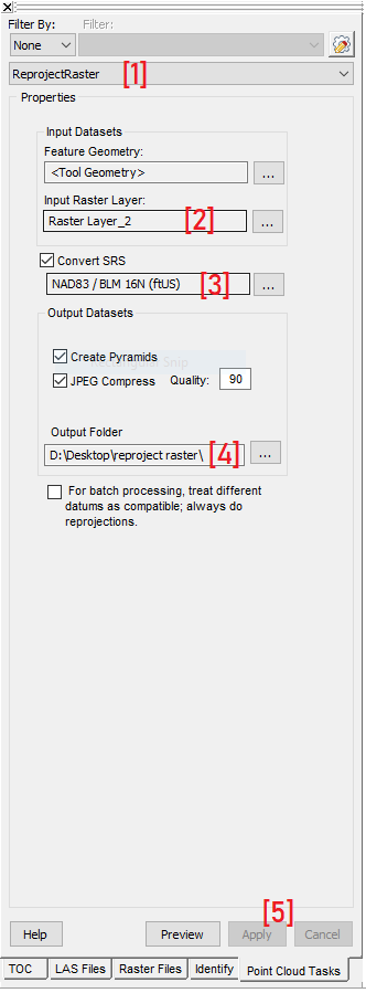
Figure 3: Reproject Raster PCT Settings
- After you have made these selections press “Apply” at the bottom right of the PCT properties page (Figure 3, #5) to save the edits to the PCT.
- Then, select Execute Point Cloud Task by Active Layer
on the Point Tasks Tab of the ribbon.
- The point cloud task execution will begin. Upon completion, the new raster should automatically load into your project. You can confirm the new SRS is correct by going to the new layer’s properties and select the “SRS” tab once again.
Note: LP360 does not perform on-the-fly reprojections for raster layers, so the placement of the new image may not appear correct if compared to data that has a different SRS.
Comments
0 comments
Please sign in to leave a comment.