
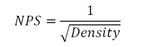
In the LIDAR industry the generally accepted definition for Nominal Pulse Spacing (NPS) is the one detailed in the USGS base LIDAR Specification. That is the spacing between points in the collection when in reference to single instrument, single swath, first return only LIDAR point data. The NPS is a value that is usually predicted by the system manufacturer's flight planning software to indicate the "grid" spacing of the collected points based upon the input flight plan parameters. The NPS may also be estimated by determining the inverse square root of the density of the data if one considers only the density of only the first return, no overage points, in a one square kilometer or greater area. The USGS uses the term Aggregate Nominal Pulse Spacing (ANPS) if the acquisition was designed to achieve the desired densities by using multiple passes.
In LP360, the point density may be readily calculated using the Point Cloud Statistics Extractor Point Cloud Task or the Point Cloud Statistics tool. The key is to ensure the area being measured is large enough, and suitable for such a measurement while limiting the points being considered to those that are first return only, and from a single flight pass.
Comments
0 comments
Please sign in to leave a comment.