Requires a 3D Accuracy add-on or an LP360 Geospatial Advanced license.
Introduction
The 3D Accuracy add-on provides powerful tools for the automatic detection and 3D measurement of ground targets, checkpoints or control points. The key benefit of the 3D Accuracy license is its ability to automatically identify and measure these targets in both horizontal and vertical, eliminating the need for manual input.
This capability is especially valuable for drone operators seeking to streamline their post-processing tasks, enhance precision, and reduce time spent on manual measurements.
What Does the 3D Accuracy Add-On Provide?
The 3D Accuracy add-on allows users to automatically detect different types of Ground Control Targets (GCTs). This tool can be found in the Control Point dialog, to access go to the Control Point tab and later select Accuracy Estimation.
The 3D Accuracy add-on will be used when selecting the "Auto Find" button, and it will provide a quality report in 3D, showing statistics for X, Y and Z. Without the add-on license, Auto Find will only perform a delta Z analysis.
Figure 1: Auto Find in the LP360 Control Report dialog
Before running the detection, users must set the correct GCT Type in the Control Point dialog from the available 3D GCT types:
- AS: Accuracy Star
- ST: SmartTarget
- CB: Checkerboard
- CV: Chevron
- CO: Concentric Circle
Can I measure Control Points without 3D Accuracy addon?
Yes, it is possible to measure control points just with LP360 Drone base license. However, the points will be automatically measured in the Z axis, or they can be measured manually in the X&Y using the "Measure mode" tool.
The main problem of trying to measure control points in a point cloud is the visual location of the targets. When working with LiDAR we cannot trust the colorization of the point cloud, since that comes from a camera, which is a different source with a different error than the laser scanner that produces the LiDAR point cloud. That is why most of the users will use the "intensity" values to measure the targets.
This has a drawback, the user may not be able to identify manually the center of the target. The closest analogy is the photogrammetry workflow when the user measures the GCPs in the photos to adjust the model. However, it is not a 1 to 1 situation, since the photogrammetry workflow sees the targets in a photo, that can easily recognize the center of the target, but in the LiDAR that is not that easy to find.
Figure 2: Checkerboard view in a photo and in the LiDAR point cloud
What type of GCT can be use with the 3D Accuracy?
A Ground Control Point (GCP) is a monumented point for which geodesic coordinates are known with a controlled accuracy and precision. It can be provided by a National Geodetic Authority or made by the user. Several topographic survey techniques can be used to determine the coordinates of a GCP (GNSS, geodetic network adjustment from distance, angle measurement, etc.). A GCP can be used for 3D accuracy assessment in surveying and mapping projects.
2D LiDAR GCTs
GCPs were first used in photogrammetry to achieve the same goal: What is the deviation between a GCP and an orthophoto produced by a photogrammetry process? The most common target used in photogrammetry for UAV collected data is the checkerboard. Another 2D Target is the concentric circle.
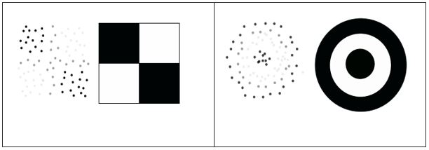
Right: Concentric Circle and typical point intensity.
When used with the 3D Accuracy add-on license in LP360, starting in v2023.2, you can achieve automated vertical and horizontal accuracy checks and improvements to your LiDAR data.
3D LiDAR GCT and Accuracy Star
Accuracy Star is a target specially designed for drone LiDAR projects to be installed on your tripod over your ground control points or check points. When used with the 3D Accuracy add-on license in LP360, starting in v2023.1, you can achieve automated vertical and horizontal accuracy checks and improvements to your LiDAR data.
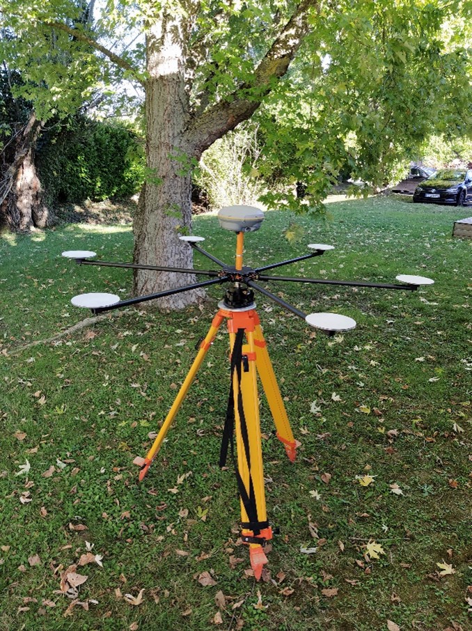
The reference position of the GCP is given by GNSS processing. The reflectors are used to compute the geometric center of the hexagon from the LiDAR point cloud.
Recommended Point Density
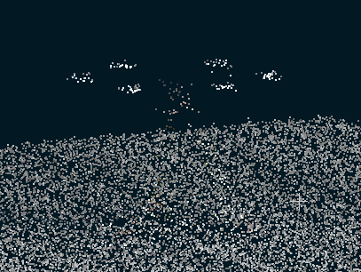
The effectiveness of the Accuracy Star is influenced by flight height and speed, which directly affect point density. The recommended minimum point density for using the Accuracy Star is generally 100 points per square meter, with some recommendations suggesting increasing this to 200 points/m² depending on the sensor and flight conditions. Quality indicators for the Accuracy Star’s center estimation include warnings like “Low density warning” and “Low density alert” when the point density is insufficient to reliably estimate the center of the Accuracy Star.
How to use the 3D Accuracy add-on
How to use Control Points for Drone/Land projects
Accuracy Star Measurement Utility
Article about 3D accuracy in Drone LiDAR projects
Comments
0 comments
Please sign in to leave a comment.